I’d be remiss if I ended these posts about the Caucasus Mountains without mentioning something cool, albeit minor, that we visited — Chalaati Glacier: noteworthy enough to be one of Mestia’s popular attractions, yet not quite noteworthy enough to merit its own Wikipedia page.
Glaciers are an unusual thing. Even more so in the Caucasus, which have time and again proven to be quite a strange “little” range. There’s 637 glaciers in Georgia as of 2015 (which is probably going to be a lot less in a few years), but the distribution is bizarrely concentrated to certain areas. Due to the insane topographic variation among Georgia’s mountains, there aren’t actually a lot of areas that are high enough elevation with the right conditions to actually support the formation and continuation of glaciers.
I know that some of you may not be reading this for glacier facts, but I love them. Glaciers are the absolute coolest. I’ve been totally nerding out while reading up on the geography of the Caucasus these last few posts, so I’m gonna subject you all to (probably) the last geographical tangent of this blog for the time being.
How Many Types of Glacier Are There?
Bet you didn’t realize there’s actually different categories of glaciers.
Or maybe you did and I’m the idiot who never considered that they might not all be under the same classification.
Regardless, I’m gonna lay them out even though we’re only talking about one type of glacier today. This is gonna be very abridged, because the study of glaciers is a literal separate field of geoscience.
Ready? Here we go.
All glaciers can be placed into one of two broad categories, based on the internal temperature of the ice. You’ve got Polar Glaciers, whose ice always maintains an internal temperature well below its melting point. Then you’ve got Temperate Glaciers, whose ice is much closer to its melting point. Temperate glaciers also tend to be the ones that are mobile — they melt and slide down the mountain, obliterating anything in its path.
The other way to classify glaciers depends on location and size. The largest of all glaciers are Ice Sheets, or Continental Glaciers. These are the massive ones that cover Greenland and Antarctica. Most of North America used to be covered in these absolutely massive glaciers called the Laurentide and Cordilleran Ice Sheets — it’s their recess that’s responsible for the great plains east of the Canadian Rockies.

Then you’ve got Ice Shelves, which are huge sheets of ice that float on water. These are usually extensions of ice sheets that extend off the coast over the water. They can reach thicknesses of 1,000m. They’re so massive and historically stationary that when they actually detach from the main body of ice, it’s cause for alarm.
When large chunks of ice detach, it’s called a calving. It’s common in places like Glacier Bay, Alaska where glaciers run right down to the ocean. A 2012 documentary called Chasing Ice features the largest calving event ever recorded, where a piece of ice 3,000 feet thick (915 meters) with a footprint the size of Manhattan Island broke off and overturned. It’s hard to really grasp the scale even when you’re watching it, but it’s a big deal that they caught it on tape. If you finish this post and decide you wanna know more, give Chasing Ice a watch. It’s what’s really piqued my interest in glaciers and it documents some seriously large-scale research. It’s good.
More recently, National Geographic captured photos of an iceberg three times the size of Manhattan breaking off the Pine Island Glacier in West Antarctica. That’s millions of tons of ice. It took a rupture covering miles and miles to separate it. At about the same time, a piece the size of the US state of Delaware broke off the Larsen C Ice Shelf in Eastern Antarctica. That’s insane, and cause for some serious concern.
Just to give you an idea of how big these are (and also how much as been lost), check out this projection of antarctic sea ice made by the National Oceanic and Atmospheric Administration (NOAA). Ice sheets and continental glaciers are just massive. But what we’re focusing on today is much smaller scale: Mountain Glaciers.

Mountain glaciers have their own sub-categories, depending on the geography of the mountains in which they are located. There’s Cirque Glaciers, the smallest, which occupy the hollow divets and depressions in the sides of mountains, called cirques.
Then you’ve got Valley Glaciers. When a glacier gets too big for its cirque, it can start to flow down the valley in a path determined by the existing topography.
Lastly, there’s Piedmont Glaciers, which happen when a valley glacier flows far enough down the mountain to exit the valley and start to collect on the slopes at the foot. For a good example, here’s a photo my brother snapped of a Piedmont-esque portion of Langjokull Glacier during our first round of travels together in Iceland back in 2016, in the days before I had a camera of my own.

For a good comparison of the three, check out this handy diagram from some lecture materials I found on Glendale Community College Arizona’s geoscience site:

The glacier we’re going to be talking about today falls into the Valley Glacier category, though it’s receding so much that it’s close to being a Cirque Glacier once again. 😦
Georgian Glaciers
Now, back to Georgia. I almost forgot what I was really writing about here.
I said that despite being incredibly mountainous with over 600 glaciers, their distribution across the Georgian Caucasus are pretty uneven. The Enguri River Basin (remember, the river we talked about in the last post) has 42% of Georgia’s glaciers, amounting to 62% of the country’s total glacial surface area. There’s four major river basins in Georgia — the Enguri, Rioni, Kodori, and Tergi — that are home to 89% of Georgia’s glaciers and 97% of glacial surface area.
I don’t know about you, but I’m having a hard time tracking the metrics here — comparing location of the number of glaciers versus the total surface area of glaciers is confusing for me. But essentially, the vast majority of Georgia’s individual glaciers are in these four river basins. The glaciers in these basins are also the largest in the country, so they total most of the surface area. The very few glaciers that exist outside of these basins are tiny.

The Kodori River Basin is shown in purple. That region is Abkhazia. The Enguri and Rioni River Basin is in yellow. The northern half of that region, which is where the high elevations are that allow glaciers to exist, is Svaneti. That’s where Ushguli and Mestia are, and where we are today. The Tergi River Basin is part of the greater Mktvari River Basin, shown in light green. The Tergi River is also called the Terek River. Sound familiar? It’s in the Khevi Region, where we saw that mountaintop church.
Without even intending it, we visited some of the most heavily-glaciated regions of Georgia!
So let’s take a look at one particular experience on one glacier in particular: Upper Svaneti’s Chalaati Glacier.
To The Trail
Located up in the Chalaati Valley about 15 kilometers from Mestia is the Chalaati Glacier. You can hike all the way from Mestia to the glacier in about six hours, but we hitched a ride to the trail head with Georgia’s two most colorful citizens. The owner of our hostel set it up for us. When we stepped out in the morning, we were greeted by two women in neon orange, pink, and yellow, standing in front of a tiny pink car with a diesel rumble fit for a truck. Georgian synth pop reverberated from the car’s speakers. The driver lowered her pink sunglasses and peered at us over the rim.
“Ready?”
We nodded and squeezed into the back seat, and off we went. To get to the Chalaati Valley, you must follow the road across the main bridge at the far end of Mestia and keep going, following the road that runs parallel to the Mestiachala River. Again, it’s hikeable, but the road is basically a long construction zone. We didn’t miss anything except 10 kilometers of gravel by taking a car.
Eventually, the road comes to an end at a small collection of buildings along the river at the base of the valley — the actual start of the trail. We parked and set off, heading for the rickety old suspension bridge that runs between two massive boulders on either side of the river.


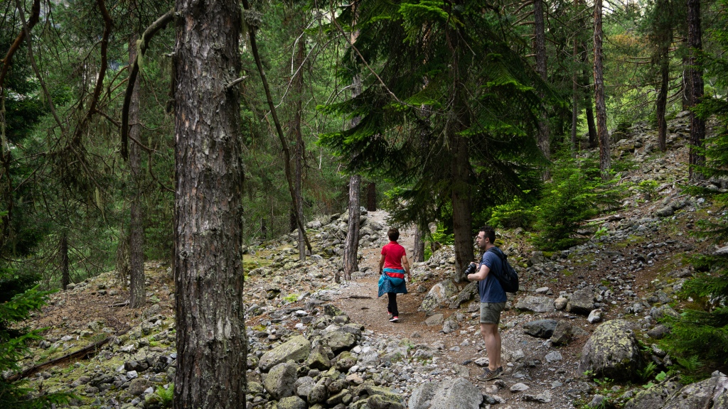
We took turns jumping through the freezing spray cast across the path by the ruptured pipe under the bridge, then set off into the woods. A lot of the path is forested, with occasional peeks at the ridges of the valley walls on either side of us.
Ascent
In the pines, it was quiet. The occasional bird chirp. Perpetual wind coming down the valley off the glacier rustling through the needles. The crunch of dead pine needles and cold dirt under our feet. Sometimes we’d pass a group of hikers, and their voices would fade in and out as they passed in and out of sight, muffled and obscured by the dense vegetation.
The path followed along the Chalaati River, supplied by the glacier. At times, we were up above it, the roaring water only barely audible. At other times, we were down next to it, hit by the spray and immersed in the roaring cacophony.


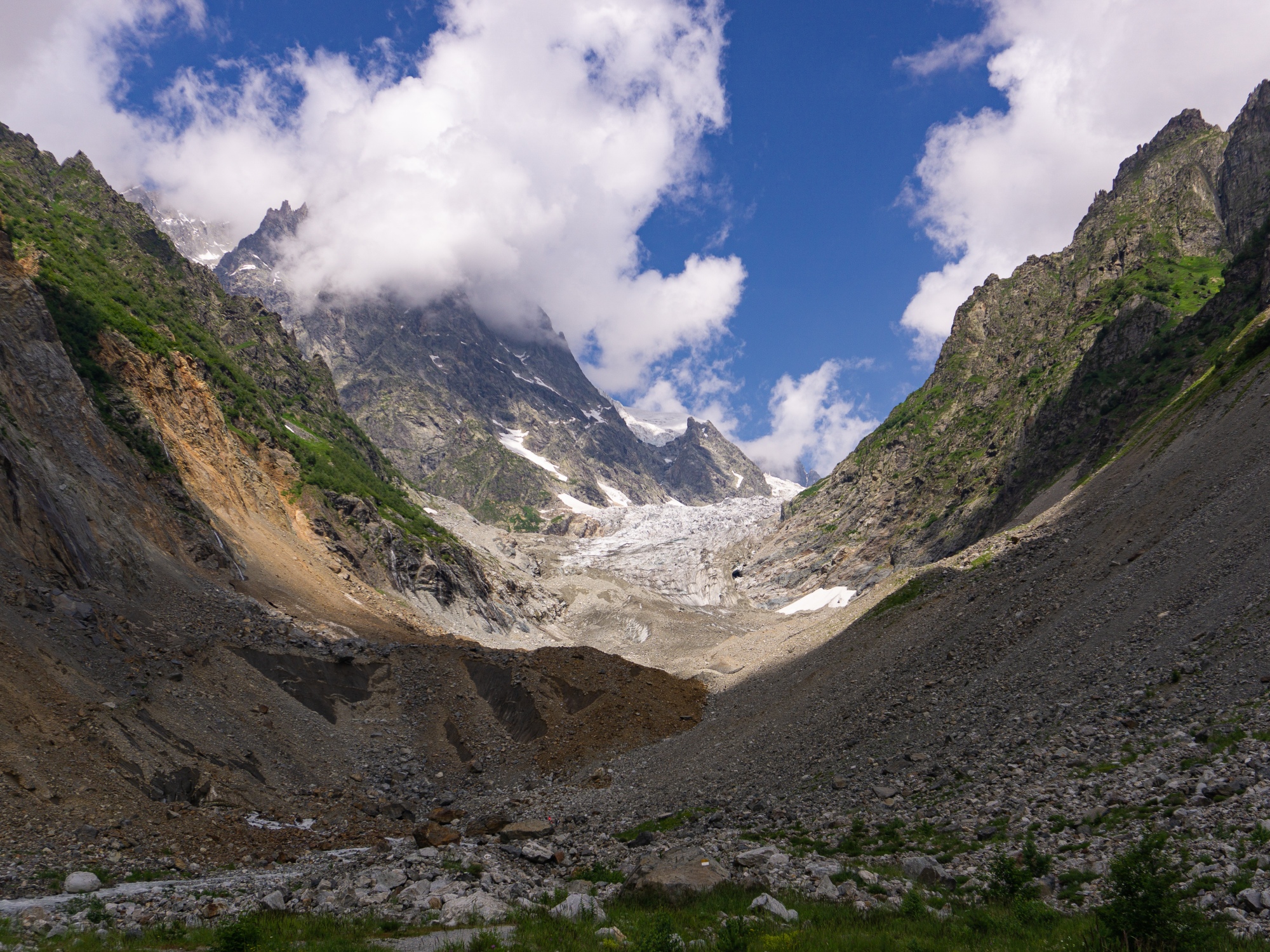
Chalaati Glacier
It really didn’t take long to get out of the forest and above the treeline. The geography and atmospherics of Western Georgia’s Caucasus are such that everything elevation-related occurs lower (due to its proximity to the Black Sea coast). It’s part of why this is such a cool and unusual glacier — it’s the only one in Georgia that actually extends down to the treeline. Chalaati Glacier is only at 1,850 meters. The general range of glaciation in Western Georgia is already absurdly low — 2,800 to 2,900 meters. It’s 3,600 meters in Eastern Georgia. But somehow Chalaati manages to exist 1,000 meters below that. It’s melting, but it’s there.
Once we got above the trees, we were immediately hit by the full force of the katabatic winds coming off the glacier. These happen when the air above the glacier gets cooled, and then moves away from being directly above it. Because cold air is denser than warm air, it “falls” from the cold base above the glacier and makes some seriously intense winds. In the wind tunnel made by the valley, without shelter from the trees, things got a lot colder for the last kilometer or so.
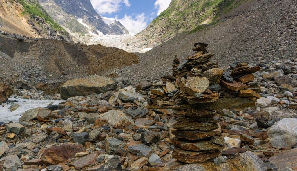
Past the trees, the rest of the trail to Chalaati is a scramble over fields of boulders left behind by the receding glacier. There’s some painted rocks here and there, but you’re basically left to find your own way across the rock field. As such, the four of us each had our own interpretations of the trail that led to the glacier with varying success.


We managed to reconnect at the far end of the scramble, where the rocks started sloping upwards towards the glacier. There were much larger boulders in this field, and I recalled a warning that the valley is prone to rockslides off the glacier in the summer. The river ran through it all, weaving its way around massive boulders and under the first fingers of ice extending down the valley.


Bright dots of colorful jackets zigzagged much further up the side of the mountain, close to the more defined edge of the glacier. We wanted to join them, but after a few minutes scrambling up the incredibly unsteady rockfall, it was apparent that it wasn’t going to be worth the trouble. Instead, we continued up a little higher to a viewpoint where we could see the glacier, unencumbered by distractions.
Here, there was absolutely no respite from the harsh wind. It whipped right through our clothes and froze my sandaled feet. Still, we stayed even when our colorful pseudo-guides vanished back down to shelter. It’s a rare opportunity to be so close to a glacier. We realized on the way up to the viewpoint that we were actually already on top of it. The ice was covered by rocks and dirt, but bare patches were exposed here and there to signal to us that we weren’t on solid (or even semi-solid) ground. Across the expanse, Chalaati Glacier looked back at us. It’s receded quite a bit — the rock fields we crossed are where the glacier used to be — but it still snakes up the valley, around the corner, and out of sight, its origin hidden between the ridges and peaks.


When we had enough of the cold, we began the precarious descent back down the rock pile. It was much slower than the way up, and several hikers on the path took sizable tumbles. I was relieved to be back in the forest and away from the unsteadiness of it all. The rock slide warning in addition to hiking up actual rock falls was enough for me.
The other thing is that the vast expanse of rubble in the valley just bummed me out. That’s where the glacier used to be. It recedes several hundred meters every year. And while Chalaati is a pretty minor glacier, it’s hardly unique. Only a handful of glaciers in Europe aren’t receding. Worldwide, very few are expanding. A minority are neither expanding nor receding. Glacial recession is the global trend.
Why You Should Care About Glaciers
I don’t mean to be getting up on my soapbox while writing about this hike we did, but screw it. We in the developed world don’t often get to see tangible evidence of climate change. This is the second glacier I’ve been to (the other being Solheimajokull in Iceland), and each took several miles of hiking up ground formerly covered by ice to reach them. We in places that don’t directly rely on glaciers don’t need to be actively thinking and worrying about this. But in places like Santiago, Chile, receding glaciers are a big deal. Most of Central Chile’s water comes from glaciers in the Andes — glaciers that have receded 66% in the last 50-odd years. That’s a city bigger than Los Angeles and comparable to New York City, mind you. Every time National Geographic posts something on Instagram or Facebook related to climate change, there’s always a string of comments claiming it to be a hoax, or the result of natural warming periods that should warrant no concern. But if all of New York City had its water supply threatened and actively dwindling as a result of climate change, you bet your ass there’d be a lot less denying it.
But wait — Santiago isn’t unique either. The glaciers in the Hindu Kush Himalayas of Pakistan and India feed some of the most major rivers in the world. The Ganges, Yellow, Yangtze, Indus, and the Mekong are just a few. The rivers that are fed by Himalayan glaciers — projected to recede at least one third within a generation or two — support nearly 2 billion people in 15 countries. India, Nepal, Myanmar, Bangladesh, Thailand, Pakistan, China, and more. It’s the water supply of the most populous regions in the world.
So I’m taking this post to step back a moment from being a “travel blog” because 1) it’s not like I’m the only one who’s written about hiking in Svaneti, and 2) this is my personal thing and it’s not like a lot of people read it anyway, so why not voice my concern about something I care about?
When people talk about melting ice caps and glaciers and the residual effects like ocean level rise and dwindling water supplies, there’s almost invariably someone who feels the need to voice their opinion — supported at best by some pseudo-science — that we’re simply in some kind of interglacial warming period and that climate change isn’t real. They’re also almost invariably not from a place that’s going to be heavily affected anytime soon. But people are being affected. It’s happening now. We’re already seeing our first climate refugees from the South Pacific and from gulf coast islands in frickin’ Louisiana. Indigenous groups in the North American Arctic can no longer rely on their ways of life that have been sufficient forever.
So I’m getting on my soapbox and ranting for a minute here because glaciers are basically the thermometer that’s reading the health of the planet. And it’s reading a fever. To those of you reading this who want to go to places like Iceland, or Georgia, or Nepal — all places I have been to and loved — I implore you to keep these things in mind when you’re there. And even more so to keep these things in mind when you’re not, because we can all help mitigate the effects on these places.
I want people to be able to come to Svaneti or Iceland or Nepal in 100 years and be able to see something as awesome and ancient as a glacier. I even more want people to be able to come to these places in 100 years and see these cultures still be able to rely on the natural resources that are so important to them. Because any version of those things not being possible would be a travesty.

One thought on “Chalaati Glacier + Glaciers at Large”