
Trekking season is upon us once again and, as I mentioned in my previous post, I don’t have much time left in Nepal. Because I’ve been here close to seven months and have only trekked for four days, I’m gearing up to set out on a longer-distance trek: 15 days in Langtang National Park. There’s no official “Langtang Circuit” (as far as I know), but a friend of mine is a mountain guide who was born and raised in Langtang and this itinerary is his own creation. So it’s not really so much a “planning post” as it is an “itinerary-sharing post.”
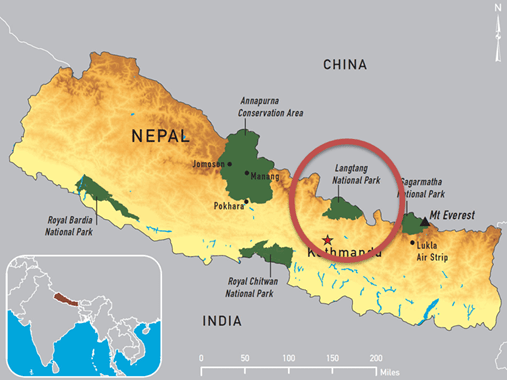
Where is Langtang?
There’s three major trekking areas in Nepal that don’t require guides or special permits to enter beyond the usual TIMS card and the relevant entry fee. Other areas like Upper Mustang, Manaslu, and Kangchenjunga require foreigners to be accompanied by a guide and carry huge permit costs (Upper Mustang costs $500). So, your average trekker (like me) doesn’t do those places.
Sagarmatha National Park, in eastern Nepal, is the most well-known due to its distinguishing feature: Mount Everest, also known as Sagarmatha in Nepali (Sagar = Sky, Matha = Head) and Qomolangma in Tibetan (Goddess of Mountain). The town of Lukla is the first stop for most Sagarmatha trekkers.
The Annapurna Conservation Area, in western Nepal, is the close second in popularity. When I last went trekking in October, this is where I went. I did the Mardi Himal Trek, but routes like Annapurna Base Camp and Annapurna Circuit are hugely popular. Annapurna is the home of the Annapurna Massif, a collection of peaks that includes Annapurna I, the 10th-highest mountain in the world. The city of Pokhara is the first stop for Annapurna trekkers.
Langtang National Park, in central Nepal, is the third major trekking area and is also the place that I know almost nothing about. It’s due north from Kathmandu and is essentially the border between Nepal and Tibet in that region. Langtang has no such gateway city like Lukla and Pokhara. In truth, Langtang is still recovering from the 2015 earthquake as it was the hardest-hit area in Nepal. Friends that have returned from Langtang spoke about trekking through the half-buried ghost town ruins whose survivors abandoned after the quake. That said, it’s a little bit less developed than its eastern and western counterparts. I’ve also been told its landscapes rival those of Sagarmatha and Annapurna.
The Itinerary
Day 1: Kathmandu to Shybrubensi. 1,600m//5,249ft.
Day 2: Shybrubensi to Kamjim (my friend’s village). 2,280m//7,480ft.
Day 3: Kamjim to Sanu Pangsang. 3,200m//10,498ft.
Day 4: Sanu Pangsang to Thulu Pangsang. 4,000m//13,123ft.
Day 5: Thulu Pangsang to Sherpagoan. 2,563m//8,408ft.
Dat 6: Sherpagoan to Thyangsyap. 3,140m//10,301ft.
Day 7: Thyangsyup to Kanjin Gumba. 3,830m//12,565ft.
Day 8: Kanjin Gumba rest day. 3,830m//12,565ft.
Day 9: Kanjin Gumba to Lama Hotel (owned by my friend’s family). 2,410m//7,906ft.
Day 10: Lama Hotel to Thulu Shybru. 2,210m//7,250ft.
Day 11: Thulu Shybru to Laurebina. 3,910m//12,828ft.
Day 12: Laurebina to Gosaikunda. 4,000m//13,123ft.
Day 13: Gosaikunda rest day to prepare for the next pass. 4,000m//13,123ft.
Day 14: Gosaikunda to Ghopte. 3,530m//11,581ft. Pass elevation: 4,610m//15,124ft
Day 15: Ghopte to Milamchigaon. 2,530m//8,300ft.
Day 16: Milamchigaon to Kathmandu.
There’s some room for flexibility built in, mainly because of the snow situation. There were some recent avalanches in the Annapurna area, and a lot of the higher elevations in Langtang are under snow. So this is gonna be fun.
Now all that’s left is to finish packing and set out tomorrow morning. I’ll be back in 16 days, maybe 17 if the weather is against us. Normally, I would post some photos here, but I don’t like looking at photos of the places I’m about to go. Ruins the surprise. So stay tuned for photos of my favorite things: mountains!

One thought on “Planning Post: Langtang “Circuit” Trek”