
Deep in the Caucasus Mountains, situated just 12 kilometers south of the Georgia-Russia border crossing at Larsi, is a valley steeped in legend and fame. It’s one of the many throughout Georgia’s mountainous maze that is the Greater Caucasus, but this one is unique.
Why is it unique? Because I went there!
But really, there are layers and layers to this particular region of Georgia that make it surprisingly interesting, as I have found only after the fact from researching before writing. I’ll build up to the actual church throughout this post.
Khevi
This is a historical-geographical region located within the much larger, official district of Kazbegi, which is in the region (mkhare in Georgian) of Mteshka-Mtianeti. In Georgian, khevi means “a gorge.” As you might guess, the Khevi region is comprised of three gorges of the three major rivers in the area, the Truso, Terek, and Snostsq’ali (have fun pronouncing that one).
Khevi is home to an ethnic Georgian group called the Mokheves, who are quite similar to the other mountaineers of Georgia’s mountains. Khevi’s culture is unique, as they have often been free from Georgia’s historically feudal governance. Instead, a khevisberi, or “Gorge Elder,” acted as a judge, priest, and general.
It’s because of this history of autonomy that Khevi has been home to fierce uprisings against the power of the day, most recently Imperialist Russia in the early 1800’s. When Georgia came under Soviet rule, the Mokheves of Khevi saw their way of life permanently altered through harsh repressions and relocations, just like the Turkmen people of Turkmenistan, the Kyrgyz people of Kyrgyzstan, and more. It’s a situation that’s been repeated across all of Central Asia as each nation and people fell under the Soviet shadow.
Stepantsminda
Located on the banks of the Terek River, one of the three major rivers that has carved out the three gorges of Khevi, is the village of Stepantsminda. There’s actually some interesting history to the name, and it runs right parallel with Khevi’s history of rebellion.
As I said above, the people of Khevi revolted against Imperial Russia from 1801 to 1804. Stepantsminda, the capital of Khevi, was governed by a lord named Gabriel Chopikashvili, son of Kazi-Beg. While the people of Khevi fought the Russians, good old Gabe remained loyal to the Tsar and helped put down the rebellion. During his rule, Stepantsminda was often referred to as “Kazbegi,” and he took it as his surname.
In 1918, Kazbegi was taken by Germany, Turkey, and the Whites, who were a political faction in Russia opposite the Bolsheviks. While the Bolsheviks had the famed Red Army, the Whites were the White Army. The two fought often.
Turkey and the White Army remained in Kazbegi until 1922, when the Soviet Union came in full force and created the Georgian Soviet Socialist Republic. In 1925, the town’s name was officially changed to Kazbegi. It did not change until 2006, when it was renamed to its current name, Stepantsminda. In Georgian, Stepantsminda means “Saint Stephan,” a famous monk in Georgian Orthodoxy.
Situated in the Darial Gorge, Stepantsminda sits at the base of two of the most formidable mountains in the Caucasus: Mount Kazbek and Mount Shani, which sit opposite each other on either side of the Terek River. The Darial Gorge itself is quite famous as being one of the two possible crossings through the Caucasus, and has been inhabited and fortified since at least 150 BC. Alexander the Great once built iron gates at an unnamed mountain pass. Darial has long been thought to be that pass. It’s been written of by saints and poets, and is perhaps one of the most famous and romantic regions of Georgia.


Tbilisi to Ananuri
In order to reach Stepantsminda, we went to the bus station at Didube. Marshrutkas gather there to disperse throughout Georgia and beyond. We took a Yandex, the Caucasus answer to Uber, to reach the station, then set off to find the appropriate Marshrutka.
Even though our destination was the town of Stepantsminda, marshrutkas bound there are labeled Kazbegi (ყაზბეგი). It’s only been “Stepantsminda” since 2006, after all.
But the thing about marshrutkas, which is not at all exclusive to Georgia, is that they only leave when they’re full. I sat in a marshrutka in Bishkek for two hours while it waited on passengers heading for Almaty. It would end up being no different here, except that we couldn’t find a marshrutka heading for Kazbegi. Instead, after a brief exchange with a marshrutka driver, we were brought to a woman who had a private car.
Maybe we totally did this wrong. I know for a fact that there are marshrutkas that go to Kazbegi, but to keep to our schedule, we opted for the taxi. Our driver told us that it would be 80 GEL (27.21 USD), but we could get it reduced if we found other passengers to share the cost. And to our driver’s credit, she spent 30 minutes on the phone, running around the bus station trying to find two or three more passengers to bring along. She wasn’t going to get any more money out of this; she was clear that it was 80 GEL for the car, not per person. She was just working extra hard to find people so we wouldn’t have to take the whole cost.
She eventually came back to the car to inform us that we were the only ones in the entire station heading to Kazbegi. We shrugged and decided that we had to keep our schedule and took the car, and the three of us were off.
Stepantsminda is 157 kilometers (98 miles) north of Tbilisi, at about double Tbilisi’s elevation, high up in the Greater Caucasus. It’s a three hour drive through the mountains. For a bit of time in the beginning, it’s easygoing through the rolling foothills around Tbilisi. The mountains start to get higher, the ridges sharper, and the ever-present Caucasus loom closer and closer. Before we really got into the mountains, our driver pulled over along a massive lake about 45 miles north of Tbilisi.
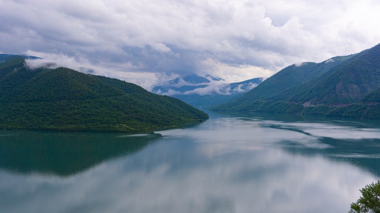
Along that lake is a castle called Ananuri.
Ananuri is a castle complex dating to the 13th century, and like everywhere else in Georgia, it’s got a wild history.
Ananuri was the seat of the Dukes (eristavis in Georgian) of Aragvi. The Aragvis were the dynasty responsible for the construction of Ananuri, and ruled the area until they came to a sudden and violent end in 1739.
A rival duchy sent soldiers under the command of a guy called Duke Shanshe of Ksani, who set Ananuri ablaze and massacred the Aragvis. Four years later, the peasants rose up, killed their new rulers, and invited King Timuraz II, a major Georgian king, to rule instead.
Duke Shanshe survived the 1743 revolt and went on to be captured by the Iranian rulers against whom he had led an earlier revolt. They gouged out his eyes and sent him back to Tbilisi in 1745 to answer for leading a rebellion against Erkle II (another Georgian king), and he died in a Tbilisi prison in 1753.
So yeah.
Ananuri is one of the many castles dotting Georgia’s landscape, and has had quite an eventful few years in the 1740’s. Nowadays, it’s a popular tourist destination and has been shortlisted for UNESCO Heritage Site status for quite some time.


Our driver only wanted to stop for 15 minutes, so we scattered into the complex to see as much of the area as possible before heading back to the car. Ananuri was the first European-style castle I had ever seen, so I was happy with it. However, it would pale in comparison to what we had waiting for us a few hours up the road.
Ananuri to Stepantsminda
Once back in the car, our driver took off at Georgian speeds into the mountains. For the next couple hours, we wound our way higher and higher. Slowly, the green of the mountains faded into gray and then white as we gained elevation on our way to Gudauri, Georgia’s most well-known ski town.
We kept following the Georgian Military Highway and crossed over Jvari Pass, the point where the road crosses from the southern plateau of the Greater Caucasus through to the northern side. As we crested the pass, the whole valley was visible below us. Rain hit the hood and clouds obscured the peaks around us. Gudauri’s ski lifts disappeared into the gray above us as our driver carefully made her way down the switchback to lower elevations.
Unfortunately for us, we were descending into one of the little microclimates that occupy each of the deep valleys of the Caucasus. It was sunny on the south side of Jvari Pass, but on the north side, it was torrential rain. Our goal was to hike up a mountain to a church near Stepantsminda, so the rain was unwelcome. When we arrived in Stepantsminda, the rain was coming down in sheets. Our driver offered to drive us up the mountain on a nearby road for some extra lari, but we declined and set off into the rain.
Thankfully, the mountain weather coin has two faces. Yes, bad weather can hit in minutes, but it can leave just as quickly. We began our walk through Stepantsminda in driving rain. By the time we reached the trailhead located behind Gergeti Cafe, the sun was out and we were sweating in the humidity. We went into the cafe to rest a moment and get dried off after the heavy rain as we prepared to hike straight up the side of the mountain to the church.
Gergeti Trinity Church (Kazbegi Church)
Located on an outcropping on the slopes of Mount Kazbek is Gergeti Trinity Church, commonly known as Kazbegi Church. Built in the 14th century, Gergeti Trinity is Khevi’s only cross-cupola church. This is a church design common to Byzantine-era churches, which is essentially a specific way to lay out the church.
Mount Kazbek, Mqinvartsveri in Georgian, is much of the draw for visitors. In Georgian folklore, a figure named Amirani is imprisoned near the peak as punishment for stealing fire from the gods as a gift for mankind (very similar to the Prometheus story from Greek mythology). Further up the mountain, beyond Gergeti Trinity, is a cave called Betlemi (Bethlehem in Georgian), which is said to be Amirani’s prison. In other legends, Betlemi once housed the tent of Abraham and the manger of the infant Jesus.
It’s also a mountaineering destination. At 5,024 meters, Kazbek is Georgia’s third-highest mountain. Another interesting metric for mountains is a thing called “prominence.” Prominence measures a mountain’s height relative to its surroundings. In Kazbek’s case, it has an elevation of 5,024 meters, which is measured from sea to summit. It has a prominence of 2,353 meters, which is measured from the actual base of the mountain to the summit.
The peak was obscured by clouds on this particular day, but you can see its slopes here.

I mention this metric because Kazbek is part of an exclusive club of “ultra-prominent” mountains, or a P1500. To be an ultra mountain, there must be a prominence of 1,500 meters or more, hence P1500. There are only 1,524 ultra mountains in the entire world. This should give you an idea of the sheer scale of Mount Kazbek and the valley around Stepantsminda and Gergeti Trinity. It’s like four walls and no roof.
In short, Mount Kazbek is extremely unusual in both its religious significance and its geographical classification.
And we had to hike right up that extreme slope.
When the rain cleared up, we left Gergeti Cafe and set off up the road towards the trailhead. As soon as you step off the road and onto the trail, it sets off straight up the mountain towards a crumbling tower on the first ridge. And it has a name! It took some digging, but I found that it is the Watchtower of Irgejuli or Irdzheuli. That’s all I could find on it. But it’s the most quintessentially Caucasian thing I’ve ever seen (the mountains, not white people).


The watchtower on the ridge, set against the extremely steep and extremely sharp slopes of Mount Shani, absolutely and completely captured my attention. It was hard to turn away from it. If that tidbit about prominence didn’t accurately convey the scale of this place, I hope these photos do. My camera lens couldn’t capture both the tower and the peaks without hiking halfway up the mountain to get far enough away.
The trail wound on, further up the side of the mountain through a gully whose river fed into the Terek down below. We had gained a lot of elevation since we left Tbilisi, and I had already lost my tolerance that I built during my year in Kathmandu, so it was slow-going. But slow-going is okay, because in the mountains, the destination doesn’t matter. When you’re in the mountains, every step is the destination.


We struggled our way higher up the mountain. Gergeti Trinity, which had been looming over us, was now obscured by the jagged ridges and rolling alpine meadows. The church sits well above the tree line, with bright green grass running flowing in the wind all across its ridge.
When we got higher and past the difficult part of the trail, we sat in the grass to take in the atmosphere. At this point on the path, there were no other visitors. The only sounds to be heard were the wind and its soft rustle through the grass. I always stop to soak in my surroundings when I’m in a truly unique place.
Over the past year, I’ve been through a lot of mountains. I spent a year in the Himalayas, and a lot of that time in the high Himalayas. To get to this point, I had to pass through the Tien Shan Mountains and Pamir Mountains. I’ve seen more of the world’s mountains than a lot of people get to see, and I was still thrown by the Greater Caucasus. The depth of the valleys and the steepness of the mountains is unlike anywhere else I’ve seen yet. I’ve reached an elevation in the Himalayas that was higher than the highest peak of the Caucasus. Yet this point, at a mere 2,000-something meters, felt much bigger than anything I’ve yet seen thanks to the crazy prominence of Mount Kazbek. I was aware of this in the moment (I usually don’t realize these things until later), which made my first push into the Caucasus that much more exciting.
We got up again and pushed up the final stretch of the trail, brushing the bristly meadow grass as we walked. All in, the hike took nearly two hours and was surprisingly difficult. My brother and I are both former college swimmers (and I am barely more than a year removed from my final season), so we felt a little humbled by the sheer steepness of Mount Kazbek. Once I develop my mountaineering abilities, Kazbek will be on my to-do list.
We reached the church and took a walk around. It overlooks all of Stepantsminda and is totally exposed to the cold wind coming off the mountains. We found that a road actually runs all the way up the mountain on the side opposite the trail we took, but the trail was so much better. Because to be honest, the hike up was far cooler (to me) than the church. But the church was super interesting nonetheless, though we only hung out for maybe 30 minutes.


Once we had our fill of the church and the view it offered, we turned back and headed down from the way we came. The steep path was difficult to navigate going down, but was also much faster. We wanted to get back to Tbilisi and have time to explore some, so we aimed to catch the first marshrutka out of Stepantsminda.
Once back on the road, we skipped our way through the streets, past the watchful eyes of cows and sheep in the fields. We also passed a car in a ditch near Gergeti Cafe that I’m almost certain wasn’t there before.
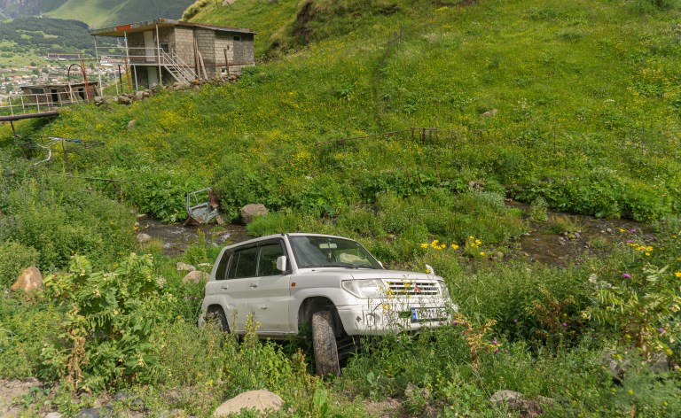
Someone was having a much, much worse day than us.
Once back on the main street of Stepantsminda, we began the long process of getting out by marshrutka. Again, they would only leave when full. But there were like five marshrutkas, all competing for the tiny number of people going to Tbilisi. My brother and I spent some time corralling other travelers, foreign and local alike, trying to assemble one full van so we could leave. It took almost an hour to convince people to stay in our van and herd others into it, but we eventually got out of Stepantminda and on the road back to Tbilisi.

5 thoughts on “Mountaintop Church in the Greater Caucasus”