
When I started writing this Langtang series, I wasn’t going to focus on individual days. But today definitely deserved its own post. I’m mainly excited to write the words “Summit Attempt” for the first time.
At the end of the Langtang Valley, even beyond Kyanjin Gomba, sits a series of mountains. Among them is Langtang Lirung (7,234m/23,734ft), Yala Peak (5,500m/18,044ft), Kyanjin Ri (4,779m/15,679ft), and Tsergo Ri (5,000m/16,404ft). Yala Peak and especially Langtang Lirung require gear and experience that we just didn’t have, and according to my friend/guide Pemba, Kyanjin Ri is “just a hill.” So we decided on our first night in Kyanjin Gomba that Tsergo Ri was the aim of the next day.
As it was explained to me (after I asked one or two too many times), Tsergo Ri is right at the line where you might make the distinction between trekking and mountaineering. I was told that making it to the top of Kyanjin Ri wouldn’t necessarily constitute “summiting,” but Tsergo Ri would be about the minimum elevation and difficulty (despite ri meaning “hill”). Minimum or not, as someone who grew up in Midwest America with outdoor ambitions revolving almost exclusively around mountain peaks and summits, getting to use the word “summit” non-ironically was a nice moment. Even if we didn’t end up making it to the summit. Not that I was upset about that or anything.
The Night Before
On the cold Kyanjin Gomba night, we sat in the lodge by the wood-burning stove, trying to keep warm in the empty room. Besides us, it was just the lodge staff and one or two guides eating dinner while their clients slept. But then the door swung open with a slam, and a bearded German man with a sunburned outline of his goggles stomped in, snow falling from his shoulders. Before even dropping his bag, he opened the cabinet and grabbed several beers. Over the course of the next hour, a dozen German trekkers squeezed into the lodge, each enthusiastically opening their beers and toasting. Their guides came next, who also received their share of beer. Pemba and I exchanged a look as we counted up the nearly 20,000 NRS (178.96 USD) worth of beer that had been emptied from the lodge’s stores.
Every one of them had a pair of crampons, chains/spikes that get affixed to your boots when ascending on ice, hanging off their packs. Never one to miss a chance to talk to people who do exactly what I want to do, I went to sit with one of the guides. When I asked where they were returning from, I was expecting Yala Peak or one of the other higher mountains in the area. The guide smiled widely, beer foam in his mustache, and proclaimed, “Tsergo Ri!”
I pointed to the crampons hanging off every pack in the room.
“Do we need those?”
Both the guide I was talking to and Pemba shook their heads. The guide himself had gone without them, but admitted they helped before taking another drink. Pemba came over to ask about the conditions on the mountain.
“Snow up to the knees, but don’t worry. We made a path for you! It will be easy!”
The Morning Of
The next morning, I awoke at 5:30 to a familiar sound that I had not heard since coming to Nepal — the soft crunch of icy snow falling. I rolled over and pushed open the blinds to see the ground outside totally covered with snow piling fast. Sighing, I laid back down. Goddamnit.
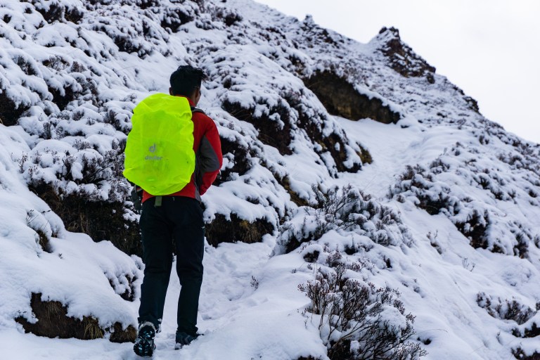
We met outside our rooms at 5:45, layered up and ready to go. I was excited to go, but the new snowfall made me a little anxious since we had witnessed an avalanche on Langtang Himal (a range of peaks above Kyanjin Gomba) the day before. Still, we set off, hoping to be at the base of Tsergo Ri before the sun had totally risen.
Crunching our way through the fresh snow, we followed the winding path that snaked down from Kyanjin Gomba, deeper into the valley. After some 30 minutes, we came to a glacial river. We took turns taking running starts and leaping across, sliding on the icy landing, before continuing on. In the rapidly-deepening snow, finding the path proved a tricky endeavor, and was made even more so by the roving herds of yaks on the mountainside. After some time scrambling up and down while evading yaks, we managed to get on a thin band of flat ground that we decided was the trail. It was also the first time we relaxed to look at our surroundings.


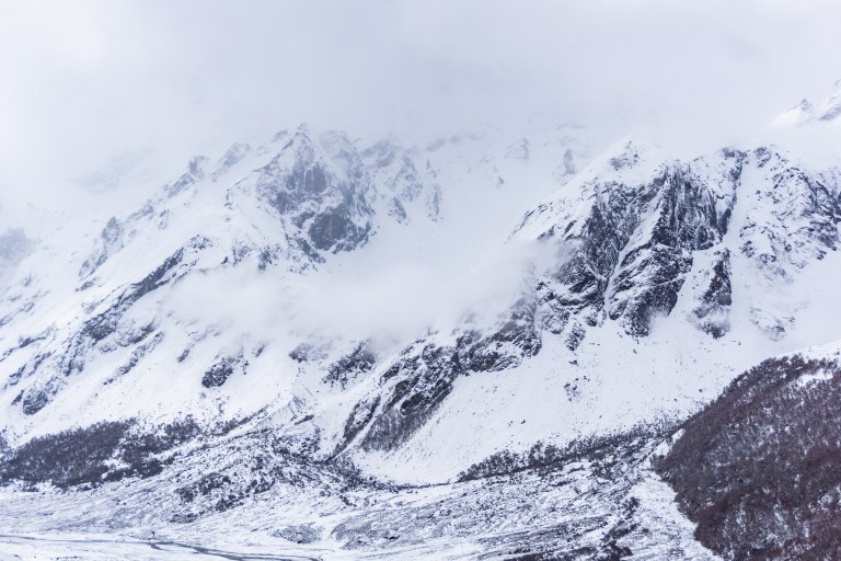
The valley stretched out for miles in every direction, cutting upwards dramatically when the floor met the white walls. The only sounds to be heard were the bells on nearby yaks, the soft crunch of snow under our feet and its soft patter as it fell, and the wind whipping across the exposed face. The sounds of the rivers of the valley were long behind us, caught in the wind and spiraling away. I took regrettably few photos during the ascent, but what I did take pulls me back to Langtang’s alpine world.
The Ascent
When we set out on the beginning of our trek, I had almost immediately gotten sick. It was nothing major, but my body’s temperature control was seriously off-balance. Even small ascents, especially as the altitude climbed, left me drenched in sweat and overheating, only to be nearly frozen when I took off my coat. Today was no such exception, and I was stopping every ten steps or so to dry my face and nose. When we hit 4,200m/13,779ft, I was already at the highest elevation I had ever visited, so every step was breaking new ground for me.

I stopped periodically to take in the view from the mountainside, and began to notice dark clouds moving up the valley. The snow on the mountain had stopped, but the clouds were closing in on us quickly. We tried to quicken our pace, but in knee-deep snow at 4,500m, any pace feels like a fast one. It wasn’t long before I was wondering if I was going to be able to make it up. We paused for some rest, and I put my coat back on to cover my sweat-soaked underlayers. I took just a few more photos before we convened a meeting about the fate of this ascent.

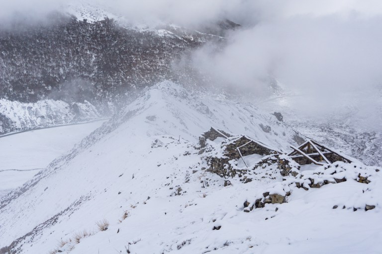
We crouched down in the snow and debated our next move. The clouds were upon us, and snow was falling hard. We had made it to, by our estimate, 4,700m/15,419ft — higher than any peak in the continental US, and would be 17th-highest in all of North America. But in the snowstorm and wind, we decided we’d go no further. Time-wise, we were only halfway, and the second half is the hard part. We reluctantly agreed to turn back, and began the shaky, slippery descent. A few minutes later, we stopped for water. In an attempt to mask my now foul mood in some faux-positivity, I offered up some glass-half-full wisdom.
“It’s snowing pretty hard. I think turning back is a good choice.”
In truth, I was pretty upset with myself for turning back. It was the first time I’ve had to turn back from something. And as a former collegiate endurance athlete, not being able to just push through the pain and discomfort as I had gotten so good at over the last four years was a bit of a hit to the ol’ ego. A lot of these thoughts had been swirling around, a cloud much darker than the one we were hiking through.
But as if on cue, a rumble came through the clouds. It began softly, but crescendoed in seconds. We sat, looking into the gray, as the now-deafening cascade shook the air. I’d be lying if I said the ground was shaking, but after experiencing several (albeit small) earthquakes in Kathmandu, I can say I didn’t feel those, but I could feel this avalanche. After nearly a full minute, the thunderous cacophony subsided, though it echoed through the valley for a moment before the snow dampened it and silence came once again. We looked at each other a moment before Pemba spoke.
“Yes, good choice.”
The Descent
The trek back to Kyanjin Gomba was one of the scarier trails I’ve taken. In fact, my top 10 scariest trails are all in Langtang. The mountain was steep, the snow slippery, and my legs exhausted. Every step was carefully planned, digging the heels in before moving the next foot forward. More than once, the packed snow collapsed under my foot and I fell, my foot or feet slipping off the trail and hanging in the air. Tsergo Ri’s trail is no more than two feet wide at the most, and drops immediately on one and sometimes both sides. This is why this was one of the scariest trails I’ve been on — on steep trails at lower elevations, you’ll hit a tree or get caught in a bush if you fall. But here, falling means not stopping until you hit the valley floor some 1,000m below.
We continued slowly and carefully, sometimes stopping to talk to other trekkers who were about to make the same decision we did. As we descended, the trail slowly became less steep, though my legs were exhausted enough that even flat ground would’ve been an issue.
We wove our way through the yak herds around the base of the mountain, then jumped the glacial river once again, a feat made much more difficult after the climb. From there, it was an hour’s walk back to Kyanjin Gomba, which gave me plenty of time to wallow in my disappointment. We of course made the right choice in turning around, but that rarely makes it any less upsetting.
The mantra of this blog is “The adventure doesn’t start until something goes wrong,” but this might’ve been the first time that was legitimately tested. But in retrospect, writing this post two weeks later, I feel fine about it. Experiences that are shitty in the moment always make the best stories, though it’s hard to remember that in the moment. But of everything that happened during our two weeks in Langtang, this is the story I’ve told the most often so far. So I didn’t get the summit, but I got a good story, and that’s what this blog is all about anyway.
