
Day 7: Kyanjin Gomba to Bamboo
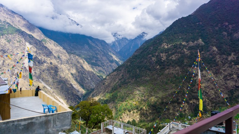
The descent is always faster and today was no exception. While it took us several days to climb up Langtang Valley, it just took one long day to descend all the way from Kyanjin Gomba (3,800m) to Pemba’s family-owned guest house, Lama Hotel (2,410m). Or rather, that was the plan, but it turns out Lama Hotel (and every other guest house in that collection of buildings) was a popular spot and we arrived too late for a room. We relaxed and ate lunch with his family and then kept on going to Bamboo, another hour and a half descent. And what a rough descent it was! Though all the people we passed on their way up looked much more unhappy, so we were on the better route.
Once we made it down to the riverside, Bamboo wasn’t much farther. When we started hiking through a forest of tall, needle-thin trees and I got excited because we were staying in a place called Bamboo in a bamboo forest. But it wasn’t bamboo. Something similar to America’s aspen trees. After the papaya-pumpkin misadventure, I think IDing obvious shit just isn’t my strong suit.
Once in Bamboo along the river, we had the usual dal bhat and hung out under the stars for awhile before going to bed. It was the last official night of the Langtang Valley trek, and tomorrow was to be the beginning of the Gosaikunda trek. I had been assured that it was harder than Tsergo Ri, so I went to bed anxious.
Day 8: Bamboo to Thulu Shybru
We awoke to rain and sat with tea and chapati while we waited it out in the lodge. Once it finally passed, we set off. Bamboo is situated directly on the low point where two very steep paths meet. Yesterday we descended for nearly seven hours, and today we were heading right back up again. In the post-rain humidity, any sort of ascent was a tough process. Still, after only an hour or two, we came to a lone lodge and stopped for water and lunch. Pemba pointed across a chasm to a village on the other side.
“There is Thulu Shybru. Looks very close, huh?”
Narrator: It was not close.
After we left and continued, the path kept winding further and further down the steep valley that separated us from Thulu Shybru. Soon, the village was out of sight and we were enclosed in the valley once again. But after some time, a suspension bridge — 100m long and at least 75m above the river — came into view. Our group with a Canadian guy and his guide who we met in Bamboo had become spaced out, and when it was my turn to cross, a large and slow cow was blocking my way. At a pace of about a meter per every five seconds, I had plenty of time to enjoy the swaying bridge and its various holes where pieces had fallen away to the river below.
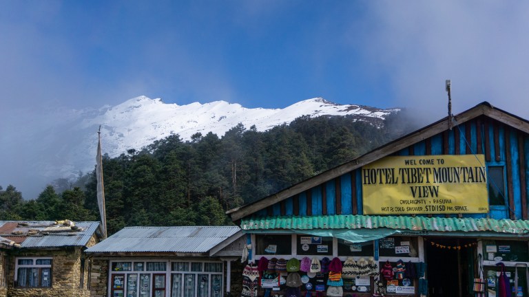
Once across, it was only another hour to Thulu Shybru. The village is up on a mountainside opposite Sherpagaon, and is more or less the beginning of Gosaikunda.

In the second photo, the snowy peak is Gosaikunda Pass. From our hotel rooftop in the surprisingly large village of Thulu Shybru, our destination looked very far away. We were only at 2,210m and Gosaikunda was nearly 4,000m. But within the next three days, we would hike up and over it. We each retired to our rooms and had the first (and only) actual shower of the trek, dinner, and then early bed.
Day 9: Thulu Shybru to Laurebina
Today was going to be the big ascent towards Gosaikunda. We woke early and had breakfast quickly, wanting to take advantage of the clear weather to make good progress before it warmed up. Thulu Shybru is built right up the steep side of the mountain, and the paths towards Gosaikunda don’t get any easier. We moved pretty slowly, but always maintained a self-imposed competition and pushed to stay ahead of a large French group with whom we had been sharing the trail since Bamboo.
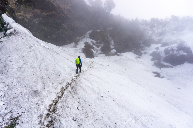
As we picked up elevation, the path steadily turned from dirt and mud to snow and slush. Much of it was still frozen, and the path was nothing but a series of footholds carved by trekkers who came before us. I didn’t know it yet, but that was a preview for what the majority of the next several days would look like.
The path wound up through the forest, which was now composed of pines and evergreens. It seemed to get steeper and steeper the higher we went, until the path became a switchback to compensate. That steepness, though, was the end marker, and soon the path emptied onto a flat expanse where a small settlement called Laurebina sat at 3,910m.
Above Laurebina was the pass, which was quickly covered by clouds. Pemba explained that we needed to leave early the next day because the pass is far too difficult to navigate under cloud cover. Because the ground is covered in snow, we couldn’t use the paths to find the way so landmarks in the mountains were our only option.
We spent much of the day and night with our new Canadian friend and his guide. Their objective was only Gosaikunda Lake, so we would see them the next day, but cross the pass alone. I was told the ascents of the next few days might be difficult, so I went to bed early to recover as best I could.
Day 10: Laurebina to Gosaikunda
This was the day where the Gosaikunda trek got good. Laurebina was right at the edge of the treeline, so once we started up, the view changed completely. The last few days had been in the jungle and the forest, sometimes catching a view of the valley from a bare patch on the path. But today, we hiked up an exposed rockfall where we stood level with the peaks that separate Nepal from Tibet.


Manaslu to the west, Ganesh Himal to the north, Langtang Ri to the east, and every major peak in between was easily visible. There were some to the northeast that Pemba said were actually in Tibet, not Nepal. So we were looking into Tibet and the Tibetan Himalayas, which is closer than a lot of people get despite being across a massive valley.
We continued upwards, until the path leveled out and cut along the side of a deep gorge. It narrowed as we continued, until eventually we were walking on a ridge made of snow, no wider than my two feet. On one side, the steep wall of the mountain. On the other, a sharp drop to the rocks below.

Thankfully, it was not far to Gosaikunda, and soon the tin roofs of the village came glittering in the sun at the end of the valley. The path wound its way under precariously-balanced boulders and past ice chunks melting into intricate designs. It sloped upwards for just a little longer, then we came to Gosaikunda, a collection of small lodges in the ridges above a frozen alpine lake.
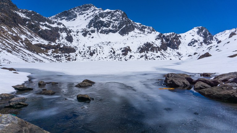
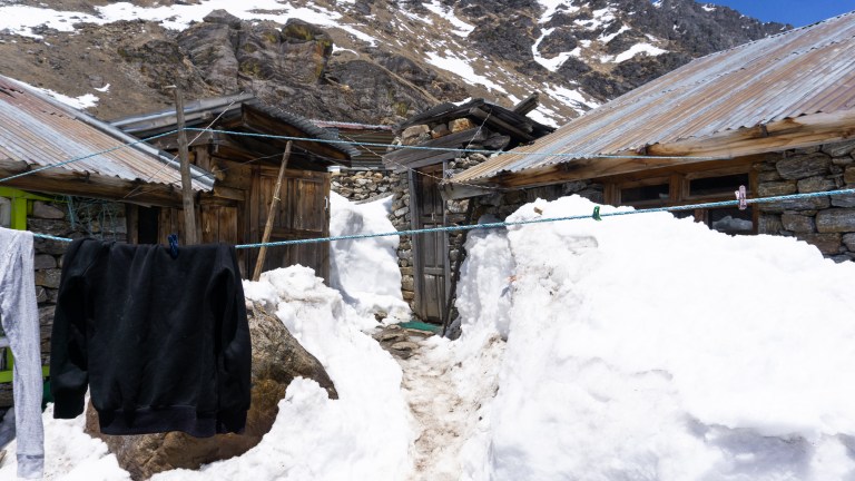
Of course, even at 4,000m, everything is frozen, not just the lake. The floors and walls of the bathroom, the window of my room, and every surface outside — ice. Successfully using the squat toilet with sore legs and a frozen floor was trying, and running in place while pooping is as un-fun as it sounds.

Once we had dropped our stuff in my crooked, frozen rooms, we went to sit in the sun. Lodges have wood-burning stoves, but usually won’t put in a fire until nighttime unless it’s busy. So, spending the afternoon on a rock in the sun like a lizard was the best option since Gosaikunda was seriously cold.
We sat awhile, warming our fingers with metal cups of tea and passing the time. We walked along the lakeshore and Pemba visited the temple outside the village. I listened to music and drank tea. But as the sun started to set, the sky came alive. Blue hour’s mellow, cool tones were broken by a streak of orange cutting across the sky, the clouds of the valley breaking on the rocks below us like waves. Large crows circled overhead and the wind blew.


We went inside once the sun got lower and found a mostly-full teahouse. I pointed out the sunset to a photographer from the large Korean group that was occupying the lodge and many cleared out to take photos. We took our places at the newly-vacated spots by the stove and ordered dinner.
After I finished, I sat by the fire for a long time. My room was far too cold to return to unless I was going to sleep. Instead, I hung out with the guides by the fire. Many of the Koreans in the lodge had gone to bed, leaving me sitting in on the guide dinner. That’s one unfortunate quirk about trekking in Nepal — guides generally must wait until all clients have eaten before they can. In this case, that meant waiting until 10:00 PM for dal bhat, the predetermined guide meal.
I didn’t stay much longer after their dinner was finished. The fire was dying and we had a long day ahead of us. I went back to my icebox and re-packed my bag for the next day then got into bed, careful not to shatter my only blanket.
Day 11: Gosaikunda to Ghopte via Gosaikunda Pass
Gosaikunda Pass is easily the coolest part of the entire 12 days I spent in Langtang. I’ve done plenty of hiking around Nepal and the US, but an actual mountain pass was a first. Gosaikunda sits at 4,340m, and to cross the pass, we had to ascend to ~4,600m before going down the other side to a village called Ghopte.
I was warned that this was going to be difficult, but amazingly it was the easiest part of the trek for me. We started up a path on the other side of Gosaikunda Lake, climbing the ridge above it until we came to yet another frozen lake. There’s something like 17 lakes scattered throughout the area, but we had seen the largest already. Once at the second lake, the path rose upwards yet again, until it came to a large, flat expanse. In the open white space walled in by craggy mountains, it felt more like an Antarctic expedition than a Himalayan trek. Another group ahead of us showed the way; colorful coats on the snow far away. It definitely would’ve been difficult to navigate under cloud cover.
The path meandered along, rising a little but mostly flat as we approached a large rocky outcropping adorned with thousands of prayer flags. This was the highest point of Gosaikunda Pass: 4,600m/15,091ft. From there, we could see the pass slope downwards sharply on the other side of the mountain.


After we rested at the high point for a few minutes, we started off down the other side. In the melting snow, you could run and jump to slide five or ten meters and fumble your way down the ridges. But the descent was quick and we were back on dry rock within an hour, making large steps between boulders to scramble down to a village called Phedi where we stopped for lunch. I figured the hard part was over, but we hadn’t even come to the hard part yet.
The path from Phedi to Ghopte consisted of a repeating circuit: steep descent over very loose rocks, step out onto the snow leftover from an avalanche, walk across the narrow ridge, and then climb the old footholds in the ice to the next ridge and start again. On the left was the steep snow, and on the right was the exposed surface that eventually dropped over a cliff. Just like Tsergo Ri, there was nothing to stop a fall. But this time, we had the added bonus of runoff water carving its way under the snow we were walking across, making it melt from below and forming holes all the way to the ground below.
We climbed up maybe ten of these icy staircases before reaching Ghopte at long last. I went to leave my now-soaked boots by the fire and absconded with a pair of flip-flops I found in the teahouse. Slowly, people we saw in Gosaikunda began to arrive. First was the Frenchman who yelled “Finger in the nose!” at me as I passed him on the trail. Apparently it means I made it look easy. It sounds better in French. Then the rest of the French group came, some Israelis, and a Thai family. The atmosphere in the lodge was energetic and happy for the night, and the food was quite good. I returned to my room barely big enough for a bed and went to sleep.
Day 12: Ghopte to Gul Bhanjyang (Golphu)
The day began with rain and a long wait for it to pass. I was still tired from the day before, so a delay was welcome news. Still, we got up to have breakfast and prepare before heading out. We were expecting a lot of ups and downs following the path to lower elevations, capping out somewhere around 3,800m before descending again. For much of the day, we were under clouds, trudging through deep snow towards our destination. On several occasions, we saw the blue tin roof of a teahouse in the distance, only to discover that it was long since abandoned.
When we started the descent for good, the path came back below the treeline very quickly. Once we were in the pines, it was as if the snowy paths we started on had never existed. The path descended again, below the pines and into the rhododendrons, Nepal’s national tree. Every tree was in bloom, igniting the otherwise dark forestscape with small pops of red, pink, orange, and yellow. I normally enjoy the forest parts of treks less than the mountainous parts, but these few hours in the rhododendron forest might’ve been the best part of the whole thing. The descent was very steep, which would’ve been awful going up, but we just got to enjoy the flowers as we bounced our way down the mountain.
After another hour, we were jolted from the trekking vibe by an army checkpoint. We had been hiking on the road to the next village, and couldn’t pass until the guards searched our bags. Once we had all been cleared, we continued down and took the first guest house we could find. It was us and a Frenchman with his guide (the guide pictured above in aviators and a cowboy hat). Once we arrived, the owner of the guest house regaled us with tales of his multiple wives, much to the discomfort of literally everyone involved. We listened for a little while, but excused ourselves and went to walk in the village until dinner.


Once dinner was finished, no one wanted to stay awake after such a long day and we each fell into our beds, bags packed and ready to catch the bus back to Kathmandu in the morning.
Day 13: Local Bus to Kathmandu
We woke early enough for breakfast but had been warned that the local buses won’t wait if we weren’t ready when it arrived. Thunder clouds had been looming since the night before and we weren’t sure if the bus was going to arrive due to rain. But sure enough, the brightly-painted bus came bouncing around the corner, a loud horn that blasted the tune of “La Cucaracha” announcing its arrival long before we saw the bumper ordained with the words, “Road King,” “Speed Control,” and “No Woman No Cry.”
We climbed in and found some seats near the back. Because I’m much taller than your average Nepali, my legs didn’t fit into my space and I had to put one in the aisle, which was fine for some time. But local buses don’t adhere to the rules of safety that tourist buses do. The tourist buses in Nepal stop taking passengers when the seats are full. The local buses stop taking passengers when there’s literally no space left. This means people hanging out the door and sometimes riding on the roof. It wasn’t long before the aisle was completely full.
When it started raining an hour and a half into the five or six hour drive, the bus stopped and put every bag from the roof in the aisle as well, forcing all occupants against the seats. A group of tween girls behind me yelled at the driver to change the music but, when no longer satisfied, started singing their own. My earbuds at full volume were no match for the barbershop quartet renditions of “Shape of You” and other Ed Sheeran selections that they inflicted on the rest of us. We stopped for a 45-minute lunch break, and the driver disappeared for nearly an hour and a half, chain smoking and watching soccer in a little restaurant. By the time we arrived in Kathmandu, I was quite excited to get off the bus and get back to my apartment.
Except the driver dropped everyone off about 10km outside Kathmandu.
The next project was finding a taxi willing to drive us all the way to the city center on what turned out to be Nepali New Year. Most taxis said no. But not every taxi driver can resist trying to make an extra few hundred rupees off a lost white guy and we found our ride. Thankfully Pemba did the negotiating. And then nearly two hours after I arrived in Kathmandu, I was back at my apartment and taking my second shower of the month. Yeww.

One thought on “Days 7-12: Traversing Snowfalls to Gosaikunda Pass + The Return to Kathmandu”